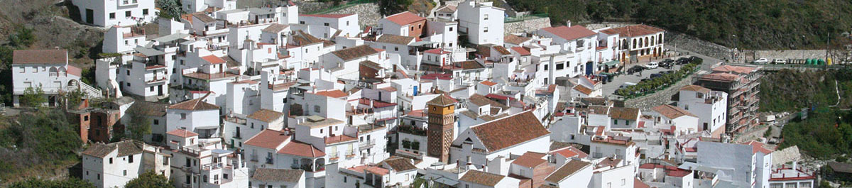
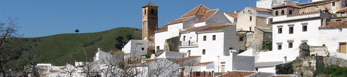
Árchez
Árchez is a small municipality of five square kilometres, and to get there, one follows the Mudéjar Route towards Salares.
Another way to reach the town is to take the road through Arenas, by Daimalos (in the municipality of Arenas) and Corumbela (municipality of Sayalonga).
Once past Sayalonga, one travels down a slight incline to Árchez, about four kilometres on.
Arenas is 11 kilometres from Árchez.
The municipality forms a triangle from south to north, in the valley of the river Turvilla, and is surrounded by the peaks of Tetuán (528 metres) and Zorra (542 metres).
There is an abundance of water in the region almost all year round. The Sierra Tejeda riverbeds are fed by the river Árchez, which takes the name Algarrobo further on.
Numerous tributaries join it along the way, such as the Cortijuelo and the Acequia de Corumbela, increasing its volume in the lower reaches.
This makes for an excellent tourist attraction, with many people visiting the area as a result.
Walking along the river banks one can see three ancient and abandoned flour mills, known as the mills of Doña Fidela, Reusto and Castrán.
The landscape in the area is mostly scrubland, with low trees here and there.
There is plenty of wildlife here too, including rabbits, hares, partridges and other birds.
Árchez is known as the Joya Merinita (Merinite Jewel) of the 12th century.
The earliest settlers here were the Moriscos, and the town probably grew up from the original farmhouse.
This explains the narrow streets and the close distribution of the houses.
The town¹s centre is small and fairly flat. One sees, walking through the town, that the design of the houses differs from street to street, some with simple roofs and others with terraces, which are of more recent construction.
Many of them have their own wells, taking water from the numerous underground streams that flow through the area.
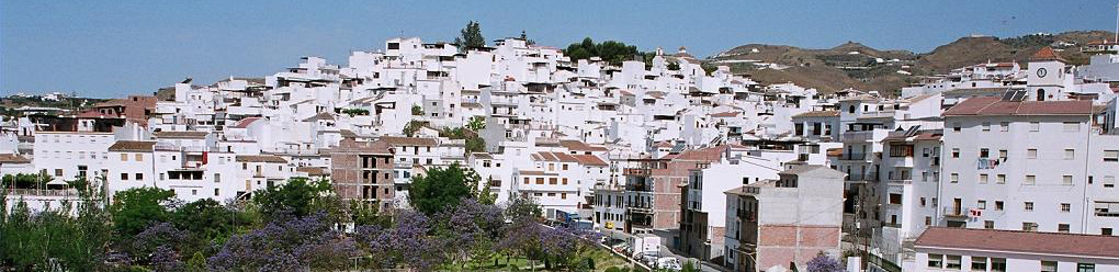
Algarrobo
The most direct route to Algarrobo is by the Autovía del Mediterráneo, heading towards Motril and following the relevant signposts. There is also a bus service to the town. Although described as a coastal town, Algarrobo is actually situated three kilometres inland, the beach area being known as Algarrobo-Costa. Algarrobo itself is at the foot of a hill that leads up to the Hermitage of San Sebastián by one of the streets in the town. The streets are narrow and winding, and most of the houses are low and white-washed, many with niches built into the facades to venerate saints.
This has been a tradition in the town for many generations. The river Algarrobo flows from the higher Axarquía east of the Vélez river through the municipality, reaching the sea along a narrow coastal strip that runs from Mezquitilla to Caleta de Vélez. It was here in the Morro de Mezquitilla that the first evidence of pre-historic settlement was found in the area, dating from the Bronze Age.
Nevertheless, the most interesting remains are to be found in the Trayamar Necropolis, consisting of a collection of tombs that extend from the Trayamar finca to a nearby hill. The Moors came later, these being of a Berber tribe known as the Beni Tumi, from which the name of the Sierra de Bentomiz derives. They stimulated the local economy by the cultivation of cereals, fruits and nuts, and the making of silk. The town passed into the hands of Doña Catalina de Ribera towards the close of the 15th century, and she had to face rebellion from the Moriscos later as a result of their expulsion and the re-settlement of Christian families.
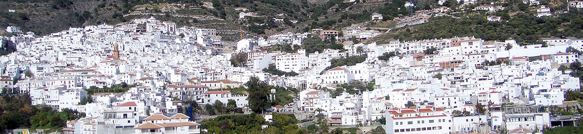
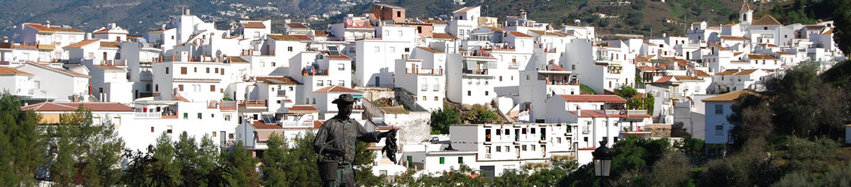
Cómpeta
The best way to get to Cómpeta from Malaga is to take the Autovía del Mediterráneo and head for Vélez. Once there, take the road to Algarrobo, passing through Sayalonga to reach Cómpeta. Cómpeta is a key point on the Ruta de la Pasa y el Vino (the Route of the Raisin and Wine) of the Axarquía. Its main industry is agriculture, especially the cultivation of grapes, and the wine produced in the region, dry and sweet and known as "vino de Cómpeta", has gained a reputation for excellence that goes far beyond the borders of the municipality. The other great product of this area is the raisin. It is produced in a traditional way with all the climatic conditions necessary for top quality raisins: sun, fresh air and good grapes.
The name of the town derives from the Latin Compita-Orum, which means "the crossing of the ways" or "the meeting place", and this was the meeting place where the Romans celebrated certain festivals and did business in. The town centre, known locally as the Cornice of the Mediterranean, covers one side of the Sierra de Almijara mountains, with the result that the streets are steep with steps in many places. It is also recommended that visitors leave their cars outside the town centre and walk. A good place to start ones visit to the town would be calle Barranco Grana, which has won various urban-embellishment prizes, or calle San Sebastián, which brings us to the higher part of the town where the views over the town and the surrounding countryside are spectacular. The Plaza de Almijara is also an essential visit, the Town Hall and Church of La Encarnación being situated here.
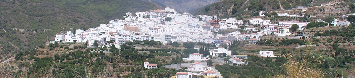
Canillas de Albaida
The Axarquía village of Canillas de Albaida is situated just four kilometres from Cómpeta, on the slopes of the Sierra de Tejeda and Almijara mountains, at a height of 576 metres above sea level. The way to get there from Malaga is along the N-340 road until you come to the crossroads at Algarrobo-Costa. Here you take the C-115 inland towards the village, which lies 21 kilometres from the coast.
On entering Canillas, one of those on the "Costa del Sol white villages" route, you come to an esplanade known as Las Esperillas, with a little shrine dedicated to the Virgin del Rosario. Not far away stands a tiny shrine to San Antón, a simple seventeenth century building. This is situated below the village, half a kilometre outside it, on the track that leads to Árchez.
The whole village is a magnificent maze of streets, twisting and winding at different levels. Calle Estación is the main thoroughfare, with numerous steep narrow alleys running off it on either side. El Callejón de Araceli is one of those which attracts most attention as it is barely possible to squeeze through between the houses on either side. All the streets lead to the Plaza del Ayuntamiento e Iglesia, the traditional village square. From here it is possible to see the shrine to Santa Ana, which dates from the sixteenth century. Remains of the original stucco lie below the layers of whitewash. Legend tells that under the shrine to Santa Ana, in the highest and oldest part of the village, there is a tunnel which nobody has ever found.
Salares
Salares is situated on a hilltop, between two riverbeds and amidst high mountains. Its position has conditioned the form that the village has taken. This means that there is no square in the centre and the streets are short and steep, most of them being formed by steps because of the tremendous differences in level. The houses are extraordinarily beautiful; some of them are whitewashed and others are decorated with tiles depicting different religious images and the Way of the Cross. Calle Puente is the flattest one in the village; it leads to the surrounding area, on the eastern slopes, and to the Roman Bridge, which still crosses over the River Salares, a water course which used to link up to the mule tracks to Alhama. The name of the village is Latin in origin and comes from "Salaria Bastitanorum," due to the existence of salt beds in the surrounding area at one time. However its layout is clearly inherited from the days of Arab rule. The Moors built a small fortress right in the village, of which one of the towers remains, near the church, forming part of the house called Del Torreón.
The history of the village parallels that of the rest of the Axarquía. Following its capture by the Christian forces, the Moriscos (Moors "converted" to Christianity) were subjected to all manner of harassment, until they finally rebelled and were subsequently expelled from Spain at the end of the 16th century. At that time, the population of Salares was 548. At the end of the 19th century the area suffered a severe earthquake, and although there was no loss of life, the town centre and numerous houses were damaged. Currently the main source of income in Salares is agriculture, especially olives and almonds, with large areas covered by vineyards.
Sayalonga
The village of Sayalonga is in the heart of the Axarquía, 44 kilometres from Malaga on the N-340 and 28 kilometres almost due east from the town of Vélez-Málaga. The village itself is situated just nine kilometres from the coast and 359 metres above sea level, while the highest point of the municipality, the hill known as La Rábita, reaches 672 metres. The village is crossed by a main street with an intricate maze of narrow winding passages on either side. A new wide square is situated at the entrance to Sayalonga and this has become the focal point of village life. The narrowest of all the streets, with low, one or two-storey houses on either side, is Calle La Alcuza, where at either end your elbows brush against the walls as you pass.
The historical origins of Sayalonga are confusing. The foundation of the settlement has been attributed to the Moors simply because no remains from earlier civilisations have been found, although the etymology of the name, Saya-longa, is clearly Latin and means "long tunic". To the west of the village lies La Rábita hill. This was the site of a sanctuary or monastery of warrior monks introduced by the Arabs from the eleventh century onwards to defend the area. It was here, at La Rábita, that the poet Ali Ibn Ahmd Ibn Muhammad Al-Hasni was born at the beginning of the fourteenth century. He was the person who wrote the history of the holy city of Mecca and also that of the Moorish governors of Malaga. When the Catholic Monarchs, Ferdinand and Isabella, conquered Vélez-Málaga, Sayalonga also fell, as did all the other local villages. In a short time the municipality was relegated to second place in the administration of the area and so the inhabitants joined in the rebellion of Arabs living under Christian rule, which led to their expulsion after the final denouement, the battle of Frigiliana, in 1569. The name Loma de Matamoros (Moor-killing hill), on the road to La Rábita, dates from this time, as do the Moorish graves nearby. King Philip II issued a royal decree in 1571 in which the goods and assets of all the Moors were confiscated and handed over to the Christians who had arrived from different parts of Spain to settle in the area. The newcomers continued with the same type of agriculture as before, creating terraces, which are still in use today. The economy of the area is based almost entirely on the vineyards, although tropical fruit have been introduced in recent years.

Sedella
Sedella is one of the 31 towns and villages that make up the Ruta Mudéjar, in the Axarquía. It borders with the municipalities of Alhama de Granada, Canillas de Albaida, Salares, Arenas and Canillas de Aceituno, to the north, northeast, east, south and west, respectively. To reach the village, one takes the autovía to Vélez and turn off there for Sedella, passing through Arenas and Árchez, or one can also take the smaller roads that run more or less parallel to the main road, these having recently been improved. As is the case of many towns in Andalucía, many of the old houses in the village have been knocked down to build new ones, but in many cases too the original Mudejar design has been preserved. Sedella is a typical Moorish town, filled with examples of Mudejar architecture, with narrow and winding streets that carry the stamp of the Moorish village. Its altitude provides wonderful views over the beautiful countryside around the village, and from here one can see the Sierra Tejeda Mountains, the Mountains of Bentomiz and one clear days, the Atlas Mountains across the Mediaterranean. It is a peaceful place, far from the hustle and bustle of the cities and bigger towns, and ideal for a weekend rest.
The history of Sedella goes back to pre-historic times, and although no big archaeological finds have been made, there is sufficient evidence to show that people have lived here from time immemorial. Among the objects found in the area are flint axes and other hunting tools. Romans and Carthaginians settled here too, as we can see from coins and ceramic pieces discovered in the area. As for the origin of the towns name, it comes from the Latin "sedilia", which means "emplacement or rural possession." There have been other names: the oldest documentary evidence we have is "Villa del Castillo", and variations on the Roman name include "Sedille", dating from the 7th century. This name appears on a map of the diocese ordered to be made by the Visigoth king Wamba. Later, the Malaga bishop Teodulpo refers to the town in an Episcopal address as "Sedilla". And following the Christian conquest in 1487, the place was called "Xedalia". But the final word on the towns name comes from Queen Isabal herself, during the re-conquest. There was, apparently, a fierce battle between Moors and Christians in the area known as the Arroyo de la Matanza. When informed of the battle, the queen replied: "Sé de ella" (I know about it).
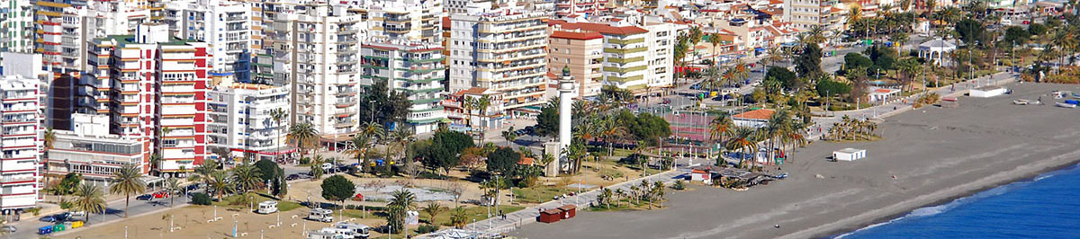
Torre Del Mar
Torre del Mar is just one of the many towns along the coast and it's name was taken from the numerous atalayas, or watch towers, which were used to guard the coast in Roman and Moorish times.
Torre is a lively town that has developed considerably in recent times. It is a fairly relaxed resort compared to those on the western side of Málaga and has a sandy beach and excellent promenade. Golf courses are in easy reach of the town, and inland are the many picturesque villages of the Axarquía, some of which are described above.

Canillas de Aceituno
The easiest way to get to Canillas de Aceituno is via Vélez-Málaga, taking first the C-335 country road and then the MA-125 local one. From the start of the latter the way climbs up to 645 metres above sea level, the height of the village itself.
The village is situated in the foothills of the Sierra Tejeda and this position gives it one of the very best views in the whole of the Axarquía, all the way from Boquete de Zafarraya, at the boundary with the province of Granada, to the coast. The municipal district of Canillas de Aceituno is surrounded by mountain peaks - Maroma (2,068 metres - the highest one in the whole of the province of Malaga, Fuerte (1,490 metres) and Rompealbaldas (770 metres).
The village is 18 kilometres from Vélez-Málaga and just 7.8 from the next-door village of Sedella. There are magnificent views of the Vélez and Rubite valleys from the road linking the two villages, with olive, almond and fig trees and vines growing beside it, all defying gravity and forming a unique landscape. The special plots for drying grapes are also found here.
The municipality is quite wooded, the trees being watered by a large number of local rivers, such as the Amánchares, the Bermuza and the Rubite, with natural springs, such as the Gazuela and the Yedra. The area around Canillas village is replete with natural caves, the main one being the Fájara, four kilometres away, with tunnels as long as half a kilometre in length.
Keep going along the MA-125 and you will soon realise that it divides the village into two parts, the road itself being the only part of the village that is flat. Once in the village, look for Calle del Convento and Calle Sierrecilla. You will get a panoramic view of the area from here and be able to pick out the Moorish legacy clearly in the layout of the streets. The Town Hall is situated in the Plaza de la Constitución, the only open space in the village. Another of the interesting streets in the village is Calle Castillo, where remains of the Arabic fortress are to be found. The street known as Calle Cementerio is in fact built over the old Arabic cemetery, from which it gets its name.
The origin of the name of Canillas del Aceituno is Canillas de Azzeitun, which means olive groves. It was not until 1569, a decisive date in the Moorish uprisings of those days, that the village was named as a significant settlement on the Marqués de Comares estate. The outstanding event in this period was a raid on the Pedro Mellado country inn, led by Andrés el Xorairán, who was born in next-door Sedella. This attack caused the wrath of the local keepers of justice, who captured and tortured eight Moors living under Christian rule, picked arbitrarily, among them the Mayor of Canillas himself. As a punishment Canillas was destroyed and left uninhabited and its castle was razed to the ground by order of Philip II in 1571.